SAT FEB 25 2012 ~1045
DOLTON FIRE DEPARTMENT
TWO-VEHICLE ROLLOVER CRASH WITH EJECTION
LINCOLN AVE AND BLACKSTONE AVE, DOLTON, IL
FRI FEB 24 2012 ~1530
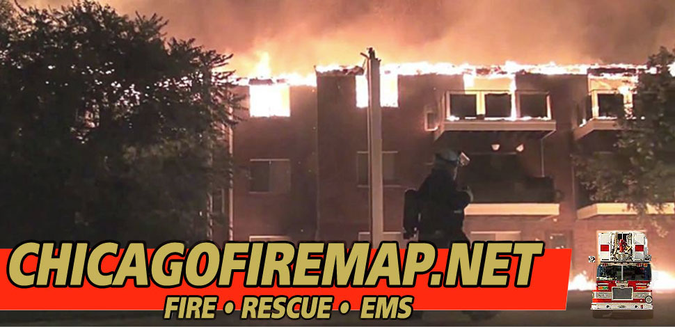
MORTON GROVE FIRE DEPARTMENT
HOUSE FIRE
9039 MASON AVENUE, MORTON GROVE, IL
FRI FEB 24 2012 ~0215
EAST HAZEL CREST FIRE DEPARTMENT
CAR VS. TOLLWAY PLAZA
HALSTED TOLL PLAZA, EAST HAZEL CREST/THORNTON, IL
FRI FEB 24 2012 ~1202
CHICAGO FIRE DEPARTMENT
SMOKE IN THE JEWEL-OSCO PARKING GARAGE
STATE STREET AND OHIO STREET, CHICAGO, IL
FRI FEB 24 2012 ~ 0900
LA GRANCE FIRE DEPARTMENT
MULTI-FAMILY BUILDING FIRE
1020 SOUTH 8TH AVENUE, LA GRANGE, IL
THU FEB 23 2012 ~2320
CHICAGO FIRE DEPARTMENT
MAJOR CRASH ON EXPRESSWAY LOCAL LANES
SOUTHBOUND DAN RYAN AND 47TH ST, CHICAGO, IL
FRI FEB 3, 2012
CHICAGO FIRE DEPARTMENT
STRUCTURE FIRE IN 3-STORY BRICK BUILDING
3941 W ARGYLE STREET, CHICAGO, IL
WED FEB 22 2012 ~2006
MARENGO RESCUE/MARENGO FPD
ROLLOVER SUV CRASH
17500 MARENGO ROAD, CORAL TOWNSHIP
THUFEB 23 2012 ~1045
HARVARD FIRE PROTECTION DISTRICT
HEAVY FIRE IN ATTIC
906 GARFIELD ROAD, HARVARD, IL
Snowfall depth forecasts have been downgraded for northern Cook County from 6"-8" to 4"-6". Most of Lake County and a small part of northeastern Cook County are in the forecast area for 6"-8". Most other regions are also downgraded, but snow is still expected.
URGENT - WINTER WEATHER MESSAGE
NATIONAL WEATHER SERVICE CHICAGO IL
905 PM CST THU FEB 23 2012
LAKE IL-DUPAGE-COOK-WILL-
INCLUDING THE CITIES OF...WAUKEGAN...WHEATON...CHICAGO...JOLIET
905 PM CST THU FEB 23 2012
...WINTER WEATHER ADVISORY REMAINS IN EFFECT UNTIL 9 AM CST
FRIDAY...
WED FEB 22 2012 ~2250
CHICAGO FIRE DEPARTMENT
GARAGE FIRES
1914 MELROSE, CHICAGO, IL
With the precipitation of the present winter storm system already beginning, the precipitation has been mainly rain across the area. Temperatures are above freezing, and snow might not begin until about 6:00 p.m. That's the good news for rush hour commuters.
The bad news is that a Winter Storm Warning could still be activated later today or this evening. The area of heaviest snow could still shift south toward Interstate 88. The timing of freezing temperatures and heavy precipitation are a major factor. One thing is certain: The snow will be heavy and wet "Heart Attack Snow."